

Across Borders
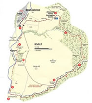
- From Newcastleton, follow the same route along minor roads to Dykecrofts as for walk 4 (1) When you reach the Forestry Commission Buildings, before Dykecrofts Farm, turn right on a track which is signed for the cycle trail.
- This track climbs behind the buildings and soon turns right to enter the Forest, heading south. Between Castle Hill and Hillhouse Wood it then swings south east to run close to a gorge on the left known as the Clintheugh Linn, before heading south again past Thwarter Gill Head and along beside the Muckle Thwarter Gill. The names are wonderfully evocative. (2) Some of the trees in this part of the forest where among the first to be planted here by the Forestry Commission in the early 1920’s. They are now classed (in terms of timber production) as over “mature”, but are being left to enhance the amenity of the area and encourage bird life. Species include Spruce, larch and Douglas Fir. Most of the cropped timber is Sitka Spruce, and the timber is used for building work, fencing material and for paper production.
- The track meets another trail coming down from the left, and this is where is starts to follow the England-Scotland Border. Cross the Kershope Burn – and walk into England! The trail runs south west, just on the English side of the border and near the edge of the forest to reach a minor road at Kershope Bridge.
- On the way it passes Dayholm, a place mentioned in the ballad of Kinmont Willie, a famous Border tale. From Kershope Bridge there are two alternatives. The most direct route is simply to follow the road as it curves gradually north as it curves gradually north below Caerba Hill to pass several discussed quarries and reach Sorbietrees. Continue with the road all the way to the Holm Bridge and onto Newcastleton.
- Perhaps the nicer way back, although it is a little longer, is to continue with the cycle trail for 2km from Kershope Bridge down to meet and other road and walk into Kershope Foot, an attractive little place, but with few facilities. Form the 1940’s to the 1960’s there was a large camp here for Forestry workers. At the welcome to the “Scottish Borders” sign, instead of crossing the Liddle Water, turn right at wheat was once a level crossing and walk along the old railway line. (4) An unusual feature of the line was that north of Scots Dyke, although it ran close to the Border it did not actually enter Scotland until crossing the Kershope Burn here, some 34kms from Carlisle. Having crossed the burn and passed through a gate you are on a low embankment across a field, this field is the historic Tourney Holm where cross border disputes were settled in the old Reiver days. Continue along the old line through Flatt Farm land with the Liddel Water close on your left until you pass Clerkleap Cottage (5) and the ruin of Mangerton Tower (see walk 8).
- At Mangerton Farm leave the railway line at take the farm road. At a ‘t’ junction turn left and head back for the Holm Bridge (7) and Newcastleton.
- Leave the track just before the stell and head left on a feint path over the moor, aiming for a gateway in the next fence line which will be become clearer as you approach it. Once through this gateway, you pick up a rough track which leads on and round to the right to another gateway. Got through and take the path that curves left.
- In about 120 metres, as the path starts to descend, you will see the Blackburn Falls down to your right. It is difficult to approach them more closely, and scrambling down the slope is only advised if you are totally confident of your footing – and of your ability to get back up again! The falls are attractive at any time but are naturally more impressive after heavy rain. Although the falls are at the confluence of Long Gill and Rough Gill, they are known locally as the Blackburn Falls. The path continues down to the site of the former buildings at Annetshiel, probably a summer shieling in former times. However, there is no continuation of this path, and unless you particularly want to see the Annietsheil site, it is best to retrace your steps from the view point above the falls. If you go down to the Annietshiels site, look for the large “knocking stone” once used to grind corn. Once you regain the stone stell the going is easier and mainly downhill, with good views across Liddesdale and the Black Burn for company most of the way back to the village and the end of the walk.
Walk Details
- Distance: 18km/11miles
- Start/Finish: Douglas Square, Newcastleton
- Terrain: Generally good paths and minor roads. Boots or strong shoes only needed in wet conditions.
- Toilet: At the start
- Refreshments: In Newcastleton
- Notes: This is the longest walk we are featuring and for part of its length it is just on the English side of the Border, so it can almost be classed as a trans national expedition! The walk follows minor roads, the old railway and a section of the Cross Border Cycle Trail, so the walking is quite straightforward.
Crown Copyright all rights reserved
Scottish Borders Council
License 100023423, 2009
