

Mangerton Tower
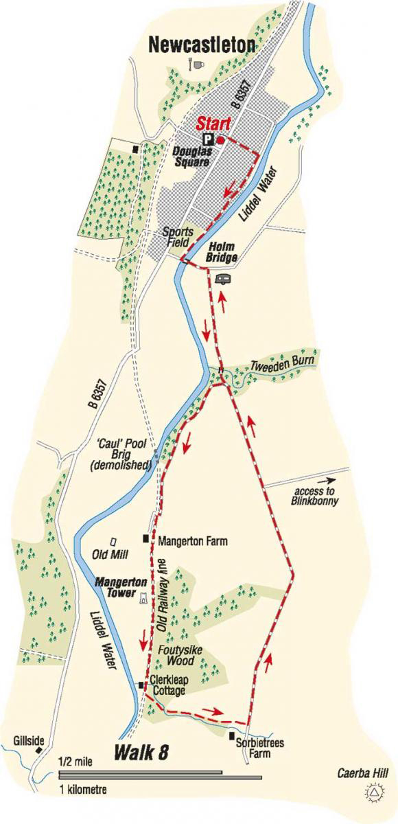
- From Douglas Square walk down to the Liddel Water and turn right. Follow the Riverside path along past the house and then beside the sports field. There are seats and picnic tables on the way.
- Climb the steps on the Holm Bridge, built in 1823, and turn left over the bridge. You will see dippers and other water birds around here. Follow the road round to the right and walk along passing a number of caravans. In about 500 metres, after crossing the bridge over the Tweeden Burn, turn right at a seat.
- The tree cover on the right hides the Liddel Water, but where the trees end, if you look right you can see where the railway line formally crossed the river. This was locally called the Caul’ Poolbrig because there was a “cauld” or weir in the river here.
- The bridge, an impressive arched viaduct was demolished in 1986. As you approach Mangerton Farm turn left on to the old railway line (“Mangerton Walk” sign).
- Walk along the old line. There are beautiful wild flowers beside the track in summer. In about 400 metres, steps lead down to the scant ruin of Mangerton Tower on the right.
- This was one of the many Armstrong fortified houses in the Borders. One of the walls carries a carved stone with the initials of a 16th century Armstrong and his wife, a Foster. The tower has been ruined for at least 200 years. Continue along the old line, with the Liddel Water over on the right, to Cirkleap Cottage.
- About 50 metres past the house go left in to the wood and left again on a rough path which climbs up to a very sharp bend, turning back right and still climbing. The path curves left again to run beside a fence with an attractive small burn on the right. The path continues climbing gently to reach a gate with a lovely view back over the Liddesdale. Walk up to a double gate at a minor road near Sorbietrees Farm.
- Caerba Hill, which has an ancient settlement on its summit, is straight ahead. Turn left along the road.
- On the way back you can enjoy the views over to the forest on the right and across the river to the hills beyond to the left. Once past the access track to Blinkbonny, the road descends steadily to rejoin the outward route at the Tweedenburn crossing. Follow the road back to the Holm Bridge and thus into Newcastleton and the end of the walk. Turn left into the main street for the end of the walk and perhaps for well earned refreshments at the inns.
Walk Details
- Distance: 7km/4.5miles
- Start/Finish: Douglas Square, Newcastleton
- Terrain: Generally good paths and minor roads. One section of rough path. Boots or strong shoes recommended.
- Toilet: At the start
- Refreshments: In Newcastleton
- Notes: This generally easy walk passes the site of a farmer Armstrong fortified house and provides a pleasant outing. Much of it is on quiet minor roads.
Crown Copyright all rights reserved
Scottish Borders Council
License 100023423, 2009
