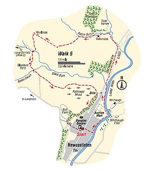
Raltonside and Blackburn
- From the north end of Douglas Square, walk down to the Liddel Water and turn left along the riverside path, passing Whithaugh Poll, at one time a favourite bathing place. Among the birds you might see are the dipper, pied wagtail, oyster catcher and heron. Across the river are the lands of Whithaugh owned by the Armstrong family in their Reiving days. Curve left with the path past the auction mart, a busy place when livestock are being sold. After about 1km the path curves left up to a stile. Reach the road and turn right to cross the Blackburn.
- In a few more metres, step off the road to the left, turn right on the old railway line and continue along it for about 800m to the Road Far road. There are beautiful banks of primroses alongside the old line in spring.
- Turn left up the Road Farm road and then left again on a track near the Railton Burn.
Pass Railtonside cottage and continue on the track close to the burn onto the open hill, where the track divides. Take the left fork which will lead you across the hill, form where you have a fine view over the valley, through a gate and across large field towards Woolhope.
- Locally pronounced, more like “Ooloch” and recorded as such as far back as 1376, Woolhope was formally a separate small farm but the building is now abandoned. Through the gate in the field corner, go down the slope on a rough track to join a better track which leads across a bridge and up hill again to Blackburn Farm.
- The medieval farm “Blackburnsyde” lay next to the burn and you pass the site of it after crossing the bridge. Pass through the farmyard taking care if there is any machinery moving about, and follow the access road over a bridge. Go through the second gate on the left beyond the bridge and follow the track down through the field. It leads through another gate and up the side of the next field beside the telephone poles.
- Go through another gate onto the Pathhead Moss. Take the track which skirts the northern edge of the Moss and leads down towards the village. Where the track bends left, go right to enter the wood by a stile and footbridge. Follow the path along the upper edge of the wood until just before a deep gulley; a small path leads down to the left. This is a short cut back to the village.
- To continue the full walk, cross two bridges and continue along the edge of the wood to the Bull Park, enclosed on the far side of a stone wall. Here the villages used to keep a bull beside the common grazing land on Holm Hill. The next bridge takes you over the mill lade which runs for 5km/3miles down the hill from where it has been diverted from the Blackburn. There were two manmade ponds nearby, one to supply water for the railway engines at the station, the other for the saw mill.
Climb the steps, cross two stiles and descend a steep bank to the Newcaslteton/Langholm road. You can see the ruined saw mill on the left. Turn left and return to the village and the end of the walk.
Walk Details
- Distance: 6km/4miles
- Start/Finish: Douglas Square, Newcastleton
- Terrain: Generally good paths. Boots or strong shoes recommended.
- Toilet: At the start
- Refreshments: In Newcastleton
Crown Copyright all rights reserved
Scottish Borders Council
License 100023423, 2009
