

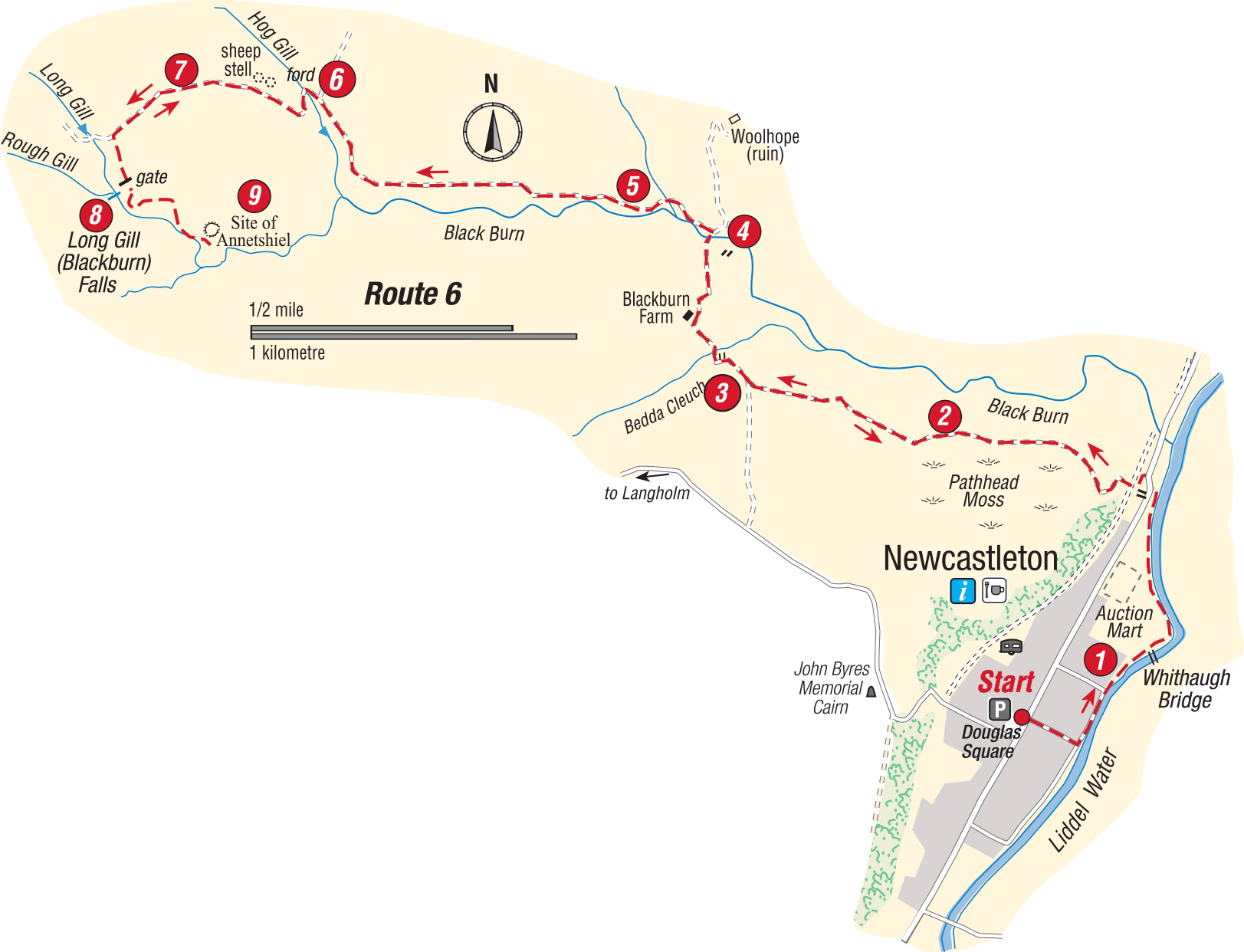
Blackburn Falls
- From the north end of Douglas Square walk down to the Liddle Water and turn left along the riverside path passing Whithaugh pool, at one time a favourite bathing place. Among the birds you might see are dipper, pied wagtail, oyster catcher and heron. Across the river are the lands of Whithaugh owned by the Armstrong family in the Reiving days. Curve left with the path past the auction mart after about 1km/.6 mile the path curves left up to a stile. Reach the road and turn right for a few metres then left (at the village sign) to cross the bridge over the former railway line. Turn left and follow the rough track up the hill, this track skirts the northern side of Pathhead Moss.
- Go through a gate in the stone dyke and follow the telephone poles along the edge of the field to another gate, go through this gate and up the next field to a third field which brings you to the Blackburn Farm road.
- Turn right, walk down to the farm, go through the farmyard (taking care if there is any machinery moving about) and through a gate between a large barn and the farmhouse. Walk down the track to the bridge over the Black Burn.
- Cross the bridge and immediately turn left on a clear track close to the barn. At a fork, keep left close to the burn (there are sheep pens to the right). Go through a gate and follow the grassy track across a field with the burn chuckling along on your left. Go thorough another gate and ahead on a very clear vehicle track climbing steadily.
- Pass through two gateways onto the open hill. The character of the landscape has changed markedly from the fields you have just left behind. Ahead are long swells of rough moorland cut through by burns, the ground rises steadily to the height of Coombs Fell and Watch Hill at over 500 metres, these are unfrequented pathless hills. As the track bends right and continues climbing, an expansive view across Liddesdale opens up to the right, at a fork go left down to the attractive little Hog Gill which is crossed at a ford.
- “Hog” here is not a reference to pigs but (also spelt hogg) is a term for a yearling sheep before it is sheared. The track curves right to a large double stone sheep stell.
- Leave the track just before the stell and head left on a feint path over the moor, aiming for a gateway in the next fence line which will be become clearer as you approach it. Once through this gateway, you pick up a rough track which leads on and round to the right to another gateway. Got through and take the path that curves left.
- In about 120 metres, as the path starts to descend, you will see the Blackburn Falls down to your right. It is difficult to approach them more closely, and scrambling down the slope is only advised if you are totally confident of your footing – and of your ability to get back up again! The falls are attractive at any time but are naturally more impressive after heavy rain. Although the falls are at the confluence of Long Gill and Rough Gill, they are known locally as the Blackburn Falls.
The path continues down to the site of the former buildings at Annetshiel, probably a summer shieling in former times. However, there is no continuation of this path, and unless you particularly want to see the Annietsheil site, it is best to retrace your steps from the view point above the falls. If you go down to the Annietshiels site, look for the large “knocking stone” once used to grind corn. Once you regain the stone stell the going is easier and mainly downhill, with good views across Liddesdale and the Black Burn for company most of the way back to the village and the end of the walk.
Walk Details
- Distance: 10km/6miles
- Start/Finish: Douglas Square, Newcastleton
- Terrain: Tracks, paths and rough ground. Boots or strong shoes recommended
- Toilet: At the start
- Refreshments: In Newcastleton
- Notes: The moorland section of this walk leading over to the falls is very exposed and sections are quite rough. It is therefore not recommended in poor weather conditions.
Crown Copyright all rights reserved
Scottish Borders Council
License 100023423, 2009
