

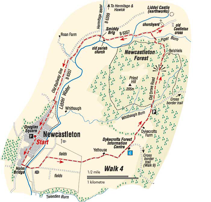
Dykecrofts and Castleton
- From Douglas Square, walk south along the main street and take the fifth road on the left to cross the Liddle Water by the Holm Brige, built in 1823.
- Follow the road uphill to Yethouse. The fields here were allocated to the villagers when Newcastleton was founded in 1793, and partly retain their pattern of narrow strips divided by fences or hedges. Just before the next cattle grid, the turf dykes of an old farm called Jingles can be seen. Continue past the former farm cottages, one of which is now a Forestry Commission visitor centre and classroom, and on past Dykecrofts Farm.
- The wood at the back of the farm is the oldest piece of forest in the area. At the car park and picnic area, take the track leading down to the Whithaugh Burn, and cross by the footbridge. Nearby on the left are several ponds where dragon flies may be seen. Carry on, following red and orange markers. After a short stony stretch the track is green and open, climbing gently.
- Once over the summit a marvellous view of Liddesdale opens before you, about 200 metres to the left, but out of view, is an ancient earthwork. Two distinctive turf walls form a channel leading a way to the right. These used to define an important drove road as it came through the cultivated enclosures of the settlement balled Belsheils, where the scant remains of two cottages can be seen near the clump of trees.
- Follow the track downhill (orange markers, often wet in this area) until it bends left. Then turn right to cross the Piper Burn by a foot bridge. Continue past Newstead up to the road. You have now left the waymarked walk.
- Turning right, up hill, for about 600 metres, along the road, would lead you to the old Castleton churchyard, with many interesting tombstones, on the site of the original parish church and manse. A short distance beyond are the green ramparts of Liddle Castle (no access) and across the road is a stone pillar the remains of a market cross. This is the last visible remains of the village of Castleton, which was removed upon the creation of Newcastleton.
- Retrace your steps down the road and continue along it, passing the old parish church which was built in 1808 and has a well-preserved mounting stone for horseman. The church was closed in 1952. In the wall of the building beside it, which once served as a school, is a stone with a Latin inscription. It can be translated as “For God and the Church, today is mine, tomorrow is yours”. It is dated 1621 and the initials of Walter Scott, minister of Castleton at that time.
- Cross the Hermitage Water, by the Hermitage Bridge known locally as the Smiddy Brig, dating from 1792 and named after an old blacksmiths workshop which once stood nearby.
- Keep left along the road for a further 2.5km to return to the village. From the Roan Farm road you can walk along the old railway line as far as the bridge over the Blackburn if you prefer.
Walk Details
- Distance: 10km/6miles
- Start/Finish: Douglas Square, Newcastleton
- Terrain: Generally good paths and minor roads. Boots or strong shoes recommended.
- Toilet: At the start
- Refreshments: In Newcastleton
- Notes: Demainholm is owned by Buccleuch Estates, and was planted in 1995, so the trees are still young. The estate has laid out two walks, one of which is described here. The walk is also still young and at the time of writing the central section was quite rough and undefined. However, it is well waymarked and is not difficult to follow. This section can also be wet underfoot after rain. For this walk, you are following orange markers.
Crown Copyright all rights reserved
Scottish Borders Council
License 100023423, 2009
